Recent updates to named areas support larger numbers of them:
- They can have tags.
- Cameo shows them as a partial table with filters on name and tags, with show more controls. (Just like many such items elsewhere in Cameo).
- The two area list sources now also select areas by tag, to save manually selecting each individually.
- Import can apply the same tag to all the areas imported.
- You can convert a closed area into an equivalent line (with co-incident end points). This allows you to search within some distance of it.
- An option allows import to treat closed areas as lines instead, avoiding the need to convert them one-by-one.
- While Cameo does not support multiple closed areas in one named area, GeoJSON does. Importing these now gives you multiple named areas.
- If the import comes from OpenStreetMap via Overpass Turbo, we include the link to the original OpenStreetMap element in the Cameo area description.
Contents
Background
Named areas primarily provide means to search geographically within or near arbitrary points, lines and/or closed areas. Manage named areas in search more → map search.
Though they have been available from almost the beginning, named areas haven’t been widely used. (It isn’t necessary for political area searches. There, the geography is handled separately in advance and searches work by text on the names of the areas located).
All named areas were shown in a table. That gets unmanageable with many more areas. We now have a use case for significant numbers of named areas.
Presentation
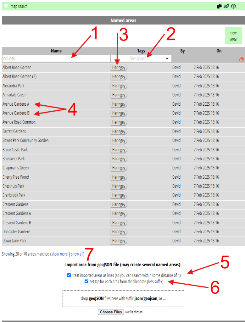
Named areas in search more → map search are now shown in an enhanced accordion-style table, like many other such tables in Cameo. This offers filters in the header (Fig 1: 1, 2) and show more and show all controls (Fig 1: 7).
Filter by name searches for partial phrases in the name. For example “Community Ga” will match Bowes Park Community Garden in Fig 1, possibly among others.
Tags for named areas
Like other groups of things in Cameo, you can now apply tags to named areas, using the same controls. Once you have some tags (Fig 1: 3), you can use them to filter the table of named areas (Fig 1: 2).
There are two list sources which work on named areas:
- areas, and
- areas including contacts
In both of these, you choose one or more named areas,. The list responds by selecting memberships within those areas. For lines and points, this means within the radius defined for the area. For example, within 500m of some road that you have drawn a line along.
Now, you can also select the areas to search within by tag. That avoids having to select each of the areas you need individually, if they are numerous.
When you import a named area, you can apply a tag to all the areas it contains. We base this on the imported file name. To do this, tick the box (Fig 1: 6) before selecting the file. For example, you have a GeoJSON file called SheffieldLakes.json, which contains outlines of lakes within the city of Sheffield. When you import it with the option turned on, each lake will be tagged SheffieldLakes.
Line vs area
When you draw the last point linked to the first on the map, the line becomes an enclosed area (polygon). That means searches then take place within the area enclosed, not near to it.
Sometimes you may want to find people who are near to some feature described by an area. While you could always do this by drawing an almost-but-not-quite closed line, you can now do it accurately. Use the button provided to convert a closed area into a line, which happens to have co-incident end points. In this way, searches are within the specified radius of the area. Note that when the area is larger than twice the radius, you will not locate people towards the centre of the area. The radius applies either side of the path, no longer within it.
Imported closed areas posed a particular problem, where you can’t use the “almost-area” hack. Now you can convert these during import. Tick the box (Fig 1: 5) before selecting the file to import to get lines with co-incident ends instead of closed areas.
You can find people who live within 500m of certain lakes, in our example, by treating their edges as lines rather than closed areas. Cameo shows the search area shaded green on the map.
Areas comprising multiple polygons
Cameo only lets you name a single point, line or closed area (polygons). Previously, if you imported a GeoJSON file in which an area comprises multiple polygons, Cameo would only have imported the first. Now it imports them as separate named areas. We add A, B, … etc to the name provided for the area in the file (Fig 1: 4).
For example, say OpenStreetMap maps two areas of water next to each other as two closed areas and a stream. However, they are actually one lake for naming purposes. Say Moorhen Lake. So OSM defines a relation (a means of combining points and areas together) which represents the lake. Importing this now makes two named areas in Cameo, Moorhen Lake A and Moorhen Lake B. You can use an area list which includes both the areas to search for people within either of them. (More likely, around them).
Sourcing areas
Named areas haven’t been used much partly because political areas often provide what you want more efficiently. But also, to move beyond drawing an outline manually on a map, you need to know how to obtain areas to import. You don’t necessarily need to know what a GeoJSON file is. However, you do need to know where and how to get hold of an appropriate one.
OpenStreetMap is a rich source of geographical outlines. But you can’t easily use this directly, even if you download a portion and isolate the bits you need. That’s because OpenStreetMap’s underlying format is XML. However, Overpass is a very useful tool for selecting appropriate items from OpenStreetMap. You can then export in GeoJSON format. Overpass is a query language for OpenStreetMap accessible through an API. However, Overpass Turbo provides a website where you can formulate and run these geographical queries interactively.
Lakes in Sheffield is exactly the kind of query Overpass Turbo is good at. (If you follow that link, click Run button to do the query). However, expressing that in Overpass’ query language is a challenge. AI has recently come to the rescue. Many AI systems are good at formulating appropriate queries from a more natural description. Nevertheless, you would probably still have to tell it that you mean both natural lakes and reservoirs. These are represented a bit differently in OpenStreetMap. And also that you mean Sheffield, England, not Sheffield, Alabama.
When you import results from Overpass, the description in Cameo’s named areas now includes the URL of the original item in OpenStreetMap.
GeoJSON.io is another useful tool for visualising and editing the contents of GeoJSON files.